
THE RILA AND PIRIN MOUNTAINS
 Samokov and Borovets
 Around Samokov
Blagoevgrad
Rila Monastery
Bansko
Kiustendil and Zemen
Melnik
Rozhen Monastery
Around Melnik
Gotse Delchev
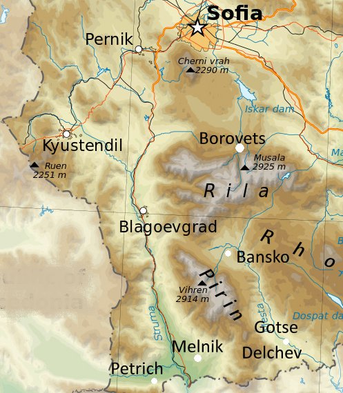
The Rila and Pirin mountain ranges are a western spur of the vast range of mountains that form almost all of southern Bulgaria. Pirin, the southern range, rises up between the valleys of the river Mesta in the east and the Struma in the west. The Struma valley is the main route into Greece. Rila, to the north contains Bulgaria’s highest peak, Mousala (2925m.) and extends almost to the outskirts of Sofia.
From Sofia the road to Samokov and Borovets winds up through the attractive Pancharevo gorge, a popular resort area for Sofians whose dachas (weekend cottages) dot the wooded slopes. At the entrance to the gorge on the hillside behind the pretty village of German lies the ancient First Kingdom Germanski Monastery, now extensively rebuilt, in whose 19th century church there are some beautiful early Samokov Icons. The road runs past Lake Pancharevo and on past the 14th century remains of Urvich castle near the village and monastery of Kokalyane, and Lake Pasarel until, just before it climbs on to the plateau of Samokov, it reaches the Iskur Dam. This hydro-electric project, known colloquially as the Sea of Sofia, was built between 1947-55 by the citizens of Sofia, whose civic duty it was deemed to be to spend their holidays and weekends at obligatory work camps excavating the dam. Now it is a popular water sports resort and boats and water skis can be hired on its shores.
SAMOKOV (Самоков)
Samokov was one of the country’s principal centres of National Revival art and craft, in particular woodcarving (of which there are fine examples by Father Antoniou in the town`s 18th century Metropolitan church and Atanas Teladuro in Rila Monastery) and the school of icon and mural painting founded in 1770 by Hristo Dimitrov and his sons Zahari and Dimitur Zograf. The name `Samokov` means a small iron mill, the town`s original industry in the 13th century, but it also became known for sheep breeding and the making of its characteristic long woollen coats, abbas. For what is today a sleepy country town, it is somewhat surprising to learn that Samokov was in the 18th and 19th centuries an intellectual centre of the nationalist revival. In 1828 Nikola Karastoyanov set up the first Cyrillic printing press and in 1844 the first Bulgarian magazine `Lyuboslovie` (Love of Literature) was published here by Konstantin Photinov. This independence of thought continued into the twentieth century when, in defiance of King Ferdinand, the town`s citizens created three short-lived socialist communes.
Samokov straddles the Iskur River, over which the main road from Sofia leads past the bus station to the centre of the modern town. A walk uphill from the bus station takes you through the public gardens which display an attractive tiled Ottoman public fountain or cheshma of 1662, past the charming Bairakli Mosque, reconstructed in 1845 by Mehmet Husref Pasha(closed Wednesdays), and into the town square dominated by the 17th century big fountain. Follow Ul. Zahariev left out of the square past the Chitalishte on your right, and you arrive at the Historical Museum whose displays trace the development of Samokov from Thracian times and include the first examples of printed Bulgarian. Retracing your steps back to the square and continuing straight across past the modern council building brings you to old Samokov and Ul. Tsar Boris III. Follow along Ul. Tsar Boris III until you see the tranquil courtyard of the Convent of Sveta Bogoroditsa, the Holy Virgin(1772) which has some colourful frescoes in the convent church, and opposite that, the 19th century period house of the Hadzhipenov family with its intricately carved eaves and ceilings. Similar houses on the other side of the street include those of the Hadzhilalov, with a graceful colonnaded portico and Obrazopisov families. A little way past the Hazhipenov house the street is dominated by the three cupolas of the elaborate facade of the church of Sveti Nicola(1861). A left turn on to Ul. Zahari Hadzhigyurov and then right on Ul. Zahari Zograf, passing the houses of Maximov, Esov and Bosev, brings you to the Metropolitan church. This eighteenth century church has a wonderfully intricate iconstasis completed in 1793 and icons that are perhaps the most characteristic in Samokov of the work of the Samokov school.
BOROVETS (Боровец)
From November to May Borovets is one of Bulgaria’s leading ski resorts and for the rest of the year it is a base for hiking, horse-riding and summer day-trips around and up nearby Mt. Mousala, at 2925 metres the country’s highest peak. Borovets, which comes from the word `Bor` meaning pine tree, was founded as a resort by Prince Ferdinand, whose Royal Hunting Lodge can be seen by taking the gondola up Mt. Yastrebets. The ski runs centre around three peaks, the nursery and intermediate slopes on Sitnyakovska Skala, and the more advanced pistes on Ystrabets and Markudyik with a total of 28 miles of pisted runs and 11 miles of cross-country tracks. The resort`s modern hotels and chalets are well-equipped and a wide range of apres-ski activities are provided including a cinema, saunas, night-clubs, folklore evenings and a panoramic tour of the area by helicopter. For the walker or horse-rider looking for unspoilt summer scenery Musala itself may be something of a disappointment, draped as it is in ski lift cables, but its rock formations are spectacular and the surrounding countryside away from the resort is beautiful. Maps of Mousala and the hiking route to Rila Monastery are available from the hotels, but care should be taken when walking these routes unaccompanied as the area is prone to sudden storms.
South of the town Tsarska Bistritsa, a former royal palace built by King Ferdinand is open to the public (Thursday to Sunday only).
South of Samokov, a mountain road, marked to the village of Govedartsi (Говедарци), leads to the resort complex of Maliovitsa. In winter this is a popular ski resort among Bulgarians and in summer an equally popular walking area on the slopes of the massif dominated by the peaks of Mt. Vazov (2670m.) in the west and Golyem Kupen (2731m.) in the east. This is delightful walking along well-marked hiking trails that bypass hidden tarns and criss-cross mountain slopes dotted with wild flowers. One of the area’s most-visited attractions are the Seven Lakes (Sedemte Ezera), accessible by a chairlift around 4 kms. from Govedartsi. The Seven Lakes, The Lower Lake, The Fish Lake, The Trefoil Lake, Twin Lake, The Kidney Lake, The Eye Lake and The Tear Lake can be walked around in one day but visitors can stay overnight in two mountain chalets (hizha) close to the lakes. In August Kidney Lake is the setting for an annual gathering of the sect called the White Brotherhood founded by Peter Dunov in 1932. Around 2000 people dressed in white gather to take part in the Paneurhythmy Dance, intended to harmonise with the rhythms of the universe. Beware of sudden storms, the higher reaches of both the Rila and Pirin ranges are renowned for the speed at which storm fronts with strong winds develop and always ensure that someone knows where you are going and wear sensible clothing.
BLAGOEVGRAD (Благоевград)
Blagoevgrad, while not being of significant interest in itself, does make a pleasant base from which to explore the western Rila, in particular the biggest and most prestigious of Bulgaria’s monasteries, Rila. The town has been heavily modernised in recent years and the new town centre is built around Blagoevgrad`s American University. East of there on the banks of the River Bistritsa is the agreeable old quarter of the town, with some pleasant cafes in National Revival style buildings and beyond that on the hill above the river overlooking the town the Bachinovo Park, a tranquil place for an afternoon stroll.
AROUND BLAGOEVGRAD
On the park side of the river, a road leads to the pretty mountain village of Bistritsa and onwards towards the Parangalitsa nature reserve around Mt. Ravnik. The road peters out after about 20 kilometres at Bodrost, just below the reserve (there are three campsites along the way and a hizha in Bodrost) and a path continues on for another 8 or so kilometres to Makedonia Hizha from where a path leads northwards over the Rodovitsa massif to join a minor road to Rila Monastery.
RILA MONASTERY (Рилски Манастир - Rilski Manastir)
Rila Monastery is the most famous and most important of Bulgaria’s monasteries, regarded by Bulgarians as the zenith of the country’s medieval culture and a living link with the glories of the Second Kingdom. Architecture and ecclesiastical history apart, it is also set in one of the most attractive mountain areas of southern Bulgaria, with many footpaths and tracks leading from the monastery through spectacular mountain scenery.
In the 10th century a monk, John of Rila (known in Bulgarian as Ivan Rilski), weary of the decadence of contemporary court and monastic life, founded a hermitage in the Rila valley some 4 kilometres upstream from the present monastery. To his disciples he preached a creed of simple asceticism which during his lifetime, despite criticism from the church establishment, drew pilgrims in increasing numbers. For 400 years after his death in 946, the hermitage remained an important spiritual centre for both Bulgarians and Serbs; the paintings in the church of Sv. Luka close by portray both Bulgarian and Serbian kings. In 1335 the hermitage was devastated by fire having earlier been partially destroyed by an avalanche and a new building was constructed on the present and presumably safer site. The feudal lord of the area, Hrelio, gave the complex the appearance of a fortress by constructing the only original part of the monastery that remains, the 23 metre/80 foot high Hrelio`s tower. Legend has it that the builder of the tower, one Hariton, so aroused the jealousy of other feudal lords that he was forced to become a monk here and then strangled, giving rise to the inscription on the tower attributed to his wife, `Thy wife sobs and grieves, weeping bitterly, consumed by sorrow`.
The monastery reached the peak of its splendour in the 14th century, when a charter granted by Tsar Ivan Shishman in 1378 gave it almost the powers of an independent kingdom. The complex was much attacked by bashibazouks during the Turkish occupation and substantial parts of it were destroyed and repaired. A final conflagration in 1833 destroyed all but Hrelio`s tower and a small chapel nearby. A public fund was started by Neofit Rilski for its rebuilding, completed in 1846, a task which was seen as a national and patriotic duty and many of Bulgaria’s finest craftsmen and builders gave their labour without payment. In 1961, the monastery was recognised by UNESCO as a World Heritage Site.
The complex retains the old high walls of the original, but this fortress-like appearance is dispelled as the visitor walks through the main gate into the flagstoned courtyard with its ornately facaded buildings, balconies with red brick columns and the rich frescoes of the red and white banded monastery church. The church has perhaps the most intricate of all Bulgarian church iconostases, carved by masters from Samokov, its almost 10 metre length gilded in sumptuous colours. It also contains the 14th century Hrelio`s throne. The external and internal frescoes depict scenes from rural life, of both local and Biblical inspiration.
The monastery treasury, beneath the modern east wing of the complex (all the facilities are open every day), has an unrivalled permanent display of ecclesiastical treasures, various charters by both Sultans and Kings, including Tsar Shishman`s 1378 charter sealed in gold, coins, weapons, vestments, manuscripts, the elaborately carved door of the original church, the first Bulgarian terrestrial globe and a wonderfully intricate miniature cross carved between 1790 and 1802 by the monk Raphael who lost his eyesight in the process. The cross depicts almost 140 biblical tableaux with more than 1500 figures, all carved with a needle. The monastery library, one of the richest in Bulgaria, contains 32,000 volumes, 9000 of which are Old Bulgarian and Slavonic manuscripts.
Beneath the north wing are the soot-encrusted old monastery kitchens with its massive cauldrons and above that on the second floor an ethnographic collection. The rooms of this wing, many elaborately decorated are named after the towns that endowed them and of particular interest is the carved ceiling of the Koprivshtitsa room.
Near the monastery are 14 small churches, some with 15th or 17th century frescoes, the most interesting of which is the little church of Sv. Luka, some 1 hours walk eastwards, with the cell and the tomb of John of Rila. Beyond the church a the road continues on to a campsite at Partizanska Polyana (partisan`s field), from where a track follows the path of the Rila river up to a particularly interesting area of the mountains, Ribni Ezera (the fishing lakes), a collection of picturesque lakes set into a bowl of the surrounding mountains. The seven lakes can be reached by a footpath leading to the north of the monastery over the peak of Ivan Vasov (Vasov Vruh - 2678 m.).
Accommodation and Getting there.
There is a small hotel near the monastery, the 3 star Hotel Rilets ( Tel. 0876 81 00 08), which is however often busy, and a camp site adjacent to it. Accommodation is available in the monastery. From Blagoevgrad regular buses run to Rila village about 12 kilometres short of the monastery, from where buses or an expensive taxi run to the monastery. From Sofia, Rila can be reached by train to Blagoevgrad (where it is perhaps easier to find a hotel room than at Rila itself) and bus thereafter.
BANSKO (Банско)
The mountain town of Bansko makes an ideal base for walkers in summer to explore the northern reaches of the Pirin range and in winter becomes the most traditional of Bulgaria`s ski resorts. Snow cover is good from December to March on a wide variety of beginner and intermediate runs on the slopes of Mt. Todorin Vrukh (2746m./8924ft.) and two long blacks and off-piste skiing for advanced skiers. The origins of the town itself lie in the 12th century although most of the older buildings in the cobbled streets around the modern town centre date from the late 18th/19th centuries when the town flourished as an economic and cultural centre. A disproportionate number of Bulgaria’s most revered sons seem to have originated from Bansko, prime among them the 18th century monk Hilendar of Paisi, whose book `A Slavo-Bulgarian History` almost single-handedly inspired the revival of Bulgarian Nationalism. A monument to him stands a little way south of the main square, Pl. Nikola Vaptsarov, named after the revolutionary poet whose museum also stands on the square. By the museum a street of the same name takes you past the Icon Museum, dedicated to the work of the local school of icon-painters led by the Vienna-educated Toma Vishanov whose work can be seen in most churches in this region.
At the end of the street is the church of Sveta Troitsa (1835) with its 30m. high bell and clock tower. Instrumental in building this church was another of Bansko`s famous sons, Neofit(-Monk) Rilski, (1794-1881) author of the first modern Bulgarian grammar, founder of the first Bulgarian school in Gabrovo and translator of the Gospels into modern Bulgarian whose museum-house stands a little way south of the church on Ul.Pirin.
Further down Pirin a right turn takes you to the Hilendar Paisi Historical Centre and further down on Ul. Aton the Radonova Kushta (Radanova House), the town’s ethnographic museum. Nearby on Ul. Velyan stands two of Bansko`s older houses open to the public, the 19th century Velianovata Kushta (Velianov`s House) and the house of one of the town`s more successful 18th century merchants, Hadzhi Vulchov.
KIUSTENDIL (Кюстендил) AND ZEMEN MONASTERY
The area around Kiustendil, in the valley of the river Bansko beneath the Osogovo Mountains, is known deservedly as the `largest orchard in Bulgaria`. In spring it is fragrant with the perfume of fruit trees and in autumn the fields and hillsides are awash with colour, the blacks and greens of vines and the yellows and reds of pear and apple trees. The Osogovo mountain reserve close to the town makes good walking country in summer with clearly marked paths up to its highest peak, Ruen (2251m.) on the Macedonian border.
The first settlement in the area dates back to 6000 BC and in the town itself to Thracian times, the first settlers presumably attracted by its thermal springs which are still one of the town`s principal attractions and its rich agricultural land. They settled on the defensible Hisarluka hill to the south of the present town and now a park. The Romans fortified the eastern part of the hill and built the Asceplion, the sacred baths, after which Emperor Marcus Aurelius named the town Pautalia - `place of springs`. Emperor Hadrian also constructed a forum and a basilica in 135 BC. Given the extensive area of the fortifications, the richness of decoration of the living quarters and the wealth of sacred objects, votive tablets and other remains found here, it must have been an important healing centre.
The Slavs renamed it Velbuzhd and built a fortress on Hisarluka. During the First Kingdom the town became an important Bishopric and remained so during Byzantine rule in the 10th and 11th centuries, as evidenced by a Byzantine note, kept in the Vatican, which states `The archbishopric in Bulgaria is called Iustinia Prima...` seated at Velbuzhd `...because the town is old and grand. Although only ruins can be seen there now, it has preserved its old beauty.` The fortifications on Hisarluka were strengthened during the Second Kingdom to repel attacks by Serb and Byzantine invaders, although it finally fell to the Turks in the 14th century who destroyed it a century later. Attracted by the climate, and healing waters a large number of Turks settled here, constructing mosques and bath-houses and renaming it Kiustendil - `Konstantine`s town` after Konstantine Deyan, lord of the region around about 1354.
The present day town centre is a pleasant tree-lined quarter, rebuilt in the nineteenth century so that not much remains of the oriental atmosphere of the old Turkish town. To the west of the main square, Pl. Velbuzhd, lies the attractively restored triple domed church of Sveta Bogoroditsa, built in 1816 by public donation as a symbol of reawakening nationalism. Behind the church is the `Maiorska Kushta`, built in 1820 as a cell school but now a community centre. A short walk eastward on Blvd. Democratsia is the `Chifte` public bath-house (daily 5.30 - 8.30 except Sun and Wed) where the hot sulphur-rich waters are said to be good for nervous and gynealogical complaints and behind that the 16th century Mosque of Ahmed Bey, now the Archeological Museum immediately adjoining the excavated remains of a Roman bath-house. Opposite the museum a side-street leads past a 15th century defensive tower, Pirgovata Kula. A little further south from here on Ul. Tsar Osvoboditel is the market and the delapidated but still impressive Fetih Mehmed Mosque from where a road takes you uphill to the Hisarluka Park.
A little way north-east of the Pl. Velbuzhd is a modern gallery dedicated to one of the area`s most famous sons, the painter Vladimir Dimitrov Maistora (1882-1960). A native of the nearby village of Frolosh, son of Macedonian refugees, Dimitrov`s early training at the Academy of Arts in Sofia was sponsored by the townsfolk of Kiustendil. He achieved international recognition when he was discovered by an American philanthropist, John Crane, who paid for four years output. He lived for many years in the village of Shishkovtsi north of Kiustendil where his house is a museum and gallery. His work, much of which is concerned with the people and countryside of his native region and characterised by strong, icon-like faces, was exhibited throughout Europe and the United States (where a considerable portion remains). The gallery has a permanent exhibition of his work and, on the mezzanine floor, a shifting exhibition of other artists from the region.
ZEMEN MONASTERY (Земенски Манастир - Zemenski Manastir)
Zemen Monastery is an easy day trip from Kyustendil, either 40 kms. by road to the village of Zemen and then by minor road east of the village, or, more impressively, on one of the 8 or so trains a day that run between Kyustendil and Zemen. After leaving the Kyustendil Plain the line runs through the 12 mile long gorge the river Struma has carved out for itself (Zemenski Prolom) between the Konyavski hills in the east and the Zemenski hills in the west. Between tunnels can be seen fantastic, often grotesque rock formations known by a variety of picturesque names and on the crags, ruins of ancient fortresses thought to be the remains of the medieval town of Zemen. Zemen Monastery is a 3 km. walk east from the present-day village of Zemen. Not outwardly impressive apart from the 12th century church, a good example of medieval Bulgarian architecture notable for the height of the drum supporting the dome, it is the frescoes inside the church that draw the eye. Painted in the time of Konstantine Deyan (see Kyustendil), they are good examples of the work of the 14th and 15th century Macedonian School. Based on folk art, the characteristically lifelike figures are expressive and highly coloured, in particular the portraits of Konstantine and his wife, Doya.
MELNIK (Мелник)
Eight kilometres south of Sandanski on the main E79 to the Greek border a minor road leads east at the village of Novo Delchevo to the little town of Melnik and the Rozhen Monastery. The approach road winds through the sandstone foothills of the Pirin range eroded into strange cone-like shapes and after a final sharp bend reveals a picturesque old Bulgarian town built into the hillside.
A town with a colourful past, Melnik was founded by the Thracians and became an important staging point for travellers from the Mediterranean northwards. In the 11th century it was a fortified village successful because of its position and defences at fending off invading Byzantine forces. Despot Alexi Slav, a feudal boyar, took over the village in the 13th century and used it as a base from which to rule most of the Rhodope (despot, in Byzantine times meant simply an emperor or absolute lord, although it appears that Alexi Slav was also a despot in the modern sense). About the same time it was colonised by Greeks, fleeing from persecution in Plovdiv, who built large and luxurious houses and endowed many churches and monasteries. During the Ottoman period, Melnik was the principal administrative centre of the district with a population of perhaps 20,000, although still accessible only by a rough track.
By the time of the liberation Melnik had begun to decline in importance, its economy hamstrung by the very inaccessibility that had been its security up until then and the rising commercial importance of the central region of Bulgaria. Its fate was sealed by a disastrous fire in 1913 which destroyed much of the town and by 1920 its population had fallen to 700. Today the 600 townsfolk exist on tourism and production of the excellent Melnik wines, fermented from grapes from a variety of vine known as `broad Melnik` grown on the hillsides around.
The best way to savour the atmosphere of Melnik is to take a leisurely stroll around its narrow cobbled streets overhung by the wooden upper stories of its old houses, stopping as often as needed in the many cafes and restaurants to sample the plentiful varieties of local wine. A gentle amble should allow you to see the two surviving churches, out of 75 in the 19th century, Sv. Nikolai and Sv. Antoni with their colourful frescoes. Close to the latter church an ancient bath house and the ruin of the 13th century Boiarskata Kushta, Boyar`s house, is probably the house of Despot Alexi Slav.
Of the many restored National Revival and older houses of Melnik, two are open to the public, the Pashov House, also the Historical Museum, at the bottom end of the main street, and the Kordoupolos House, up a path from the top end of the high street, are open to the public. The elegant rooms of the 19th century Pashov House have an exhibition of photographs and engravings of old Melnik and a reconstruction of 19th century life. The intricately carved and spacious rooms of the Kordoupolos House, their stained glass windows overlooking the town from a rocky promontory, are an excellent example of 19th century craftsmanship. There is also that staple of every Melnik house, a wine-cellar with huge wooden barrels and a secret room in which Kourdopolos, a Greek merchant with little sympathy for the Turks, could hide his family in times of trouble. Finally finish your visit with a wine tasting at the Wine Museum, a little distance from the Kordoupolos House.
ROZHEN MONASTERY (Роженски Манастир)
From Melnik there are regular buses up the valley to the Monastery or, for the more agile, a 7km path (from the Sv. Antoni Church) over the mountains through a curiously eroded sandstone landscape called the Melnik Pyramids. The Pyramids are naturally occurring sandstone outcrops in a variety of shapes, some reaching a height of 100 m. The bus drops passengers at the village of Rozhen, more rural than its neighbour, Melnik, but equally charming in a less ostentatious way and with a pleasant mehana. The villagers make their own quite distinctive wine, sold from their houses or at the mehana. From the village it is a short walk uphill to the monastery. Built on the site of an older monastery by Despot Alexi Slav in 1220, it is smaller and less ornate than its sister at Rila. The courtyard is more intimate and plainer but with the same balconied buildings housing the monks` cells and the bakery and refectory. The church has some vividly gory frescoes and an iconostasis by carvers from Debur with their characteristic use of flower and fruit motifs. A little way off from the monastery is a19th century church and behind it the grave of the Macedonian freedom fighter, Yan Sandanski.
Eight kilometres north of Melnik on the E79 the town of Sandanski (Сандански), named after Yane Sandanski, is best-known for its health-giving climate, mineral waters and for being the birth-place of Spartacus, the legendary leader of a 1st century BC slave revolt against the Romans. The town was built on an earlier Byzantine town and the remains of four Episcopal basilicas have been found. The best preserved, the central Episcopal basilica on Ul. Gotse Delchev, dates back to the 5th - 6th century AD and has interesting mosaics. The archaeological museum nearby was built on the foundations of the basilica of bishop Ioan. Many of the hotels in the town offer spa facilities and mineralised hot water springs can be seen in the Sveti Vrach park, up Ul. Makedonia from the museum. Sandanski also makes a good base from which to explore the Pirin mountains.
South of Melnik is Petrich (Петрич), in origin an ancient town although largely destroyed during the First World War. Most Bulgarians know it as the home of Bulgaria’s most respected clairvoyant, Vanga, who died in 1996. Clairvoyancy is an influential and highly regarded practice in Bulgaria and very few towns cannot boast at least one practitioner. None were more revered than Vanga, who explained her gift by saying that at the age of six an angel came to her and offered her the choice of her eyesight or the ability to prophesy. She chose blindness and clairvoyance and testament to her success was the seemingly endless queues of expensive cars that beat a path to her door, including, it is rumoured, those of senior Bulgarian and foreign politicians. Her house is now a museum on the appropriately named Ul. Vanga. For the casual visitor, Petrich`s main attraction is the ruins of Samuilova Krepost, (Tsar Samuel`s Fort) some 15kms. west of the town on a turn-off just after the village of Strumeshnitsa. It is the site of a monument to the battle of Strumitsa in 1014, one of the more awful barbarities in Bulgaria`s bloody history. (See History for more detail)
Gotse Delchev is a pleasant town in the valley of the river Mesta. Its name was Nevrokop until 1951, when it was renamed after one of Vasil Levski’s followers. This region is one of the centres of the Pomaks, Bulgarian Muslims, who grow tobacco in the fields up and down the valley and whose way of life seems to have changed little since Ottoman times. Exploring the surrounding villages is one of the delights of this area, in particular, the road through Leshten up to Kovachevitsa. Both these villages have a unique architectural style and from Kovachevitsa you can explore the stunning views the surrounding countryside offers. Saint Nicholas Church (Sv Nikola) in the village is a national cultural monument.