
PLOVDIV AND THE RODOPE MOUNTAINS
 Plovdiv
The Rodope Mountains
Bachkovo Monastery
Pamporovo
Smolyan
Rodope Villages
Velingrad
PLOVDIV (Пловдив)
Bulgaria’s second and oldest city has a vibrancy and life that is immediately attractive but without the frenetic pace of Sofia. Built on the banks of the River Maritsa on and around some rocky little hills rising unexpectedly out of the Thracian plain, the picturesque heart of the old city remains as a testament to Plovdiv`s long and colourful history even if the initial approach, through row upon row of concrete apartment blocks, is not obviously attractive. It is also a busy commercial centre, perhaps best known outside Bulgaria for its Annual Trade Fair held every September in a purpose built fair ground on the banks of the Maritsa.
A LITTLE HISTORY...
The Thracian tribe, the Odrysae, first fortified the hill of Nebet Tepe calling it Eumolpiade. In 341 BC Philip II of Macedon conquered the town and fortified two further hills, Jambaz and Taxim renaming it Philippopolis, literally `Philip`s town` under corruptions of which name it has been called since. The Macedonians` reign was short, the Thracians reconquered it at the end of the 2nd century BC and renamed it Pulpudeva. The Roman Emperor Claudius seized the town in 46 AD and in the 2nd century Marcus Aurelius rebuilt the fortifications, calling it officially Trimontium - `three hills`, although to most of its Greek inhabitants it was still known as Philippopolis.
Under Roman rule it prospered and spread on to the surrounding plain roughly covering the same area as the present city centre and the fortifications were strengthened and expanded. The town`s importance as a major trading post on the Belgrade- Constantinople road is demonstrated by the grandeur of the remaining ruins, a 30,000 seat stadium, a theatre and the site of a substantial temple to Apollo. It was however devastated by invading Huns in 447 and though rebuilt and refortified by Emperor Justinian in the 6th century, under pressure from Slav raids it never re-attained its former glory. Armenian settlers migrated to what the Slavs now called Pulpudeva (shortened successively to Pupuldin, Puldin and finally Plovdiv) in the 8th and 9th centuries, and the town retains an Armenian population to this day.
The Bulgarians, after a few abortive raids that further destroyed the city, finally captured it in the 9th century only to lose it to a Byzantine army in the early years of the 11th century. There followed a period when, in common with many Bulgarian towns of the time, the city found itself alternately under the control of Byzantium, the Bulgars and successive Crusader armies. In the 13th and 14th centuries it changed hands 11 times and thus the city the Turks finally entered in 1346 was a pale shadow of the cosmopolitan metropolis of Roman times. The Turks renamed it `Felibe`, again after Philip of Macedon and it became the seat of the governor of province of Rumelia. The stability of Ottoman rule and, again, its position on the major route between Asia Minor and Europe ensured its commercial success and its rich and well-travelled merchants were instrumental in the growth of the Bulgarian National Revival movement in the 18th and 19th centuries, commissioning houses in the Bulgarian style, actively campaigning for a Bulgarian exarchate and building Bulgarian schools and libraries. Plovdiv was liberated by the Russian army in 1878 and had the Treaty of Berlin not handed East Rumelia to the Turks, it would probably have become the capital of the new state. As it was Plovdiv had to wait until 1885 to become part of Bulgaria.
THE CITY
Modern Plovdiv has two areas of interest to the visitor, the modern heart of the city on the plain between the railway station and the Maritsa River and, above it on three hills, the Old Town (Старият Град – Stariat Grad) with its National Revival houses and Roman and Byzantine remains. Life in the modern city revolves around its main shopping street, a pedestrian precinct lined with boutiques and pleasant outdoor cafes, starting at the river by the main city market as Ul. Raiko Daskalov and becoming Kniaz Aleksander before it eventually ends at Pl. Centralen, the central square. This vast open space was laid out in the Communist years for the Manifestatsia, the displays the party leadership required of the town’s citizens on Mayday, the first Communist leader, Georgi Dimitrov`s birthday and other days throughout the year. Nowadays it is used in the summer as a fairground and for folk dance and music performances. On its western side is Tsar Simeon Park, a pleasant little park with a boating lake at its southern end. From the southern end of the square, the tree-lined Ul. Ivan Vasov leads down to the railway station and the bus stations.
Specific attractions on Kniaz Aleksander are the Drama Theatre, near the central square, venue for concerts by the city`s resident orchestra, the Plovdiv Philharmonic Orchestra, and plays (mostly in Bulgarian) during the season (September to May). At number 15 is the City Art Gallery with a permanent exhibition of 19th and early 20th century Bulgarian artists and a number of temporary exhibitions throughout the year. North of here Kniaz Aleksander opens out into Pl. Dzhumaya, dominated on its eastern side by the Dzhumaya Mosque (often closed outside prayer times), According to tradition it was built in the 15th century on the site of an earlier church, that of Sv. Petka, from where the mosque`s name is derived (Dzhumaya means Friday - `petuk` in Bulgarian). It is one of the biggest mosques in the Balkans, the prayer hall being built in the then popular style of nine squares divided by four columns. The interior decoration, a mixture of arabesques and ornate quotations from the Koran is typical of the period, as is the little fountain in the courtyard.
Near the mosque, below street level are the excavated remains of the Roman theatre. On view is only a small part of what must have been an impressive edifice, a semi-circular arena capable of holding 30,000 people in which the Romans staged the often bloody spectacle of the Alexandrine Games in the 2nd and 3rd centuries. The area around the mosque was the old Muslim quarter of the city in Ottoman times and the bazaar. Further north the zigzag brickwork of the minaret of the 15th century Imaret Mosque (imaret means pilgrim`s hostel) overlooks Ul. Han Kurbat. Westward along Han Kurbat is Pl. Suedinenie and the city`s Archaeological Museum. Established in 1822, the museum houses a chronologically arranged collection of pottery, coins and weaponry tracing Plovdiv`s history from Thracian times through to the Second Kingdom.
Three hills dot the plain within the city boundary. Sahat Tepe, (meaning, in Turkish, the hill with the clock) running parallel to Kniaz Aleksander near Pl. Centralen, gives a superb view of the city. It is topped by a clock tower, supposed to be one of the oldest in Europe. It is unclear precisely when it was erected but travellers in the early years of the Ottoman Empire mention its existence. A Turkish inscription records that it was restored in 1812 and refers to the difficulty of the work. A little further west the Hill of The Liberators is immediately recognisable because of the two monuments dominating its summit, an 18 m. (60 ft.) high granite soldier,(known colloquially as `Alyosha`) a monument to the Red Army and on a lower peak a pyramid shaped monument to the Bulgarian freedom fighters of 1878. Further to the south-west is the Hill of Youth, now a park.
The International Fair Ground, home to Bulgaria`s biggest Annual Trade Fair is across the river. Started in the 19th century the fairs attract participants from all over the world.
THE OLD TOWN
The winding streets of the old town, designated as an Architectural-Historical Reserve, are best approached from Pl. Dzhumaya, from where it is a short walk uphill on Ul. Suborna to its heart. The old town contains a wealth of National Revival buildings and Roman and Byzantine remains, best appreciated by taking half a day to stroll gently around. The often brightly painted National Revival houses whose upper storeys overhang the maze of small streets and alleyways, are decorated with floral motifs and false columns in ‘alafranga’ style, in the style of the west, as opposed to ‘allaturca’, in Ottoman style. Their decorative exteriors and sumptuous interiors with intricately carved ceilings were constructed to reflect the commercial success of their owners. Between the houses can sometimes be glimpsed sections of the old fortress walls.
A few yards up Ul. Suborna, the belfry of the Church of Sv. Bogoroditsa (the Virgin Mary) can be seen through some trees on the right. Built in 1844, it is Plovdiv`s principal church and contains some icons by one of the more prominent members of the Samokov school, Stanislav Dospevski. Further up the Chomakov House is devoted to an exhibition of works by Zlatiu Boyadzhiev, a post-war artist with a popular earthy, folky style. Beyond that, just beyond a little museum devoted to icons at number 22, is the 1832 Church of Sv. Konstantin and Elena, a colourful little church decorated with scenes from the Gospels and with some icons by Zachari Zograf. Opposite is the Tourist Information Office.
Further uphill again, just beyond a crossroads the imposing gate of the Koiumdzhioglu House, now the Ethnographic Museum (open every day but Monday), is set into a high wall on the right.
Commissioned in 1837 by the Greek merchant whose name it still bears, it was built by an Istanbul builder, Hadji George on part of the Roman fortress wall. The symmetrical curved front is typical of houses of this style built in the shape of a `Kobilitsa`, a yoke for carrying buckets of water. The interior is spacious and well lit by natural light. The ground floor rooms are given over to a display of tools and agricultural implements detailing the working life of Plovdiv and the surrounding region during the 19th century and the upper storey is part recreation of the house as it must have looked in Koiumdzhioglu`s day, complete with Viennese furniture and rich dresses and part display of Rodope folk costumes.
Further up the street on the left is the Atanas Krastev House, a former mayor of Plovdiv who was instrumental in preserving the old town, now a gallery of contemporary art. At the top of the hill are the partly excavated remains of Nebet Tepe fortress, the heart of Macedonian and Roman Plovdiv. The thick fortress walls are evident, but little else is recognisable although the view of Plovdiv from here is superb. Back down at the crossroads past the Ethnographic Museum, a right turn down Ul. 4th of January leads to the Balabanov house, now a gallery exhibiting contemporary art. At the end of the street take left on to ul. Artin Gidikov and the Hindlian House, a lovingly recreated example of a merchant’s house in 19th century Plovdiv. Stefan Hindlian was an Armenian whose travels are reflected in the murals of various cities he had painted into niches in the house. The furniture, collected from various houses in the Old Town, also reflects the cosmopolitan nature of merchant society with examples from Central Europe, particularly Vienna. Many Armenian families still live in the area, nearby are an Armenian school and church.
Taking a left turn at the crossroads leads down the opposite slope of the hill to the Georgiadi House, built also by Hadji Georgi in the koblitsa style of the Ethnographic Museum and now a museum of the National Liberation. The atrocities of the bashibazouks are remembered here in some detail as is the philanthropic help given to the Bulgarian people by foreigners, in particular Lady Strangford, a campaigner for Bulgarian independence, whose picture is exhibited and who has a street named after her in the city centre. A turn back to the Historical Museum and then left takes you past the Danchova House and the White House Cultural Centre, a contemporary gallery, and on to the Lamartine House. This is a small museum devoted to the French poet and travel writer Georges Lamartine who wrote some of his `Voyage en L`Orient` here in 1833. A short walk through the Dzhambaz Tepe Garden, is the Roman Theatre, partially destroyed by invading Goths in the 3rd century but restored in recent years. From its marble seats audiences can watch modern productions in the summer months against the impressive backdrop of the theatre’s elaborate colonnaded facade. At the top is a cafe, a pleasant place to rest your feet and admire the view of the distant Rodope Mountains. A short walk up Ul. Hemus and then left from here takes you to the Plovdiv History Museum. Back to Ul. Saborna, through the Dzhanmiya Park takes you to the Roman Stadium. This immense structure stretched down what is now Ul. Kniaz Alexander 1 for three city blocks. On your left at the bottom are the excavated remains of the Odeon of Phillipopis, the council house on Ul. General Gurko. Finally cross Ul. William Gladston into Pl. Tsentralen, the Central Square and you are in the forum.
Plovdiv was European City of Culture in 2019 and its legacy is a host of events, galleries and workshops which can be researched when you are there from Tourist Information Offices.
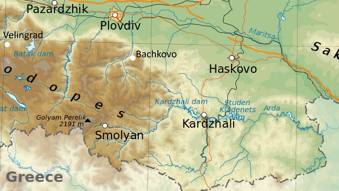
THE RODOPE MOUNTAINS (Родопи Планина - Rodopi Planina)
The Rodope Mountains stretch for 150 miles through southern Bulgaria, a vast under-populated stretch of highland some 60 miles wide. The highest peak is Golyam Perelik (7189 ft. - 2191 mtrs.) just east of Smolyan and there are another 5 peaks over 2000 mtrs. The name Rodope is Thracian in origin and, legend has it, comes from the story of two Thracian lovers, Haemus and Rodope, who flattered themselves by calling themselves Zeus and Hera. This angered Zeus, the real god, who in revenge changed the two impudent mortals into mountain ranges, Haemus, now the Stara Planina, and the Rodope forever divided by the Thracian Plain. The Rodope’s other great mythological inhabitant was Orpheus, who in legend was born of a Muse, Calliope and a Thracian King, Ogreaus, near Pamporovo. The Rodope’s principal town, Smolyan and the nearby ski resort of Pamporovo are reached from Plovdiv by a road that runs through the picturesque gorge of the river Chepelarska running south to the Greek border.
BACHKOVO MONASTERY (Бачковски манастир)
Bachkovo Monastery is a short bus ride south of Plovdiv (by Plovdiv - Smolyan or Plovdiv - Chepelare buses). On the way the road passes through the town of Asenovgrad a small tobacco producing town whose name means literally, Asen`s town. The 13th century Tsar Ivan Asen built a fortress on a rocky outcrop overlooking the gorge of the Chepelare River near Asenovgrad, the remains of which can still be seen as the road enters the gorge. A little way into the gorge is the village of Bachkovo. Its stone houses were probably built from the remains of the medieval Byzantine fortress of Petra, the site of which it occupies. The fortress was destroyed by the invading Turks, who established Bachkovo as a centre for collecting `bach`, a tax on livestock, from whence its name comes. A kilometre or so south of the village lies the monastery, like the two other jewels in Bulgaria`s ecclesiastical crown, Rila Monastery and Boyana church, a UNESCO World Heritage site.
Built in 1083 by two Georgians, Abas and Gregory Pakuriana, in the service of the Byzantine Emperor Alexius Comnenus, the monastery originally admitted only Georgian monks. In 1344 Tsar Ivan Alexandur granted it money and land and Bulgarian monks were admitted for the first time. Over the next two centuries the monastery became an important Bulgarian religious and literary centre, a position it was able to retain after the Ottoman conquest. The last Bulgarian Patriarch, Evtimi, was exiled here in 1394. In one of the Turks` periodic crackdowns on Bulgarian nationalist and religious aspirations, the monastery was destroyed in the 16th century and only the Sveta Troitsa Church outside the main gate survives from the original Second Kingdom complex. It was partly reconstructed by Greek donors in the first half of the 17th century, who sponsored the construction of the central Sveta Bogoroditsa (Church of the Assumption) and living quarters for 100 monks. In the 19th century the monastery again became a centre of Bulgarian national culture and the church of Saint Nicholas was constructed, with frescoes by Bulgarian artists.
Entering the courtyard through the nail studded door the frescoes on the refectory wall depict the history of the monastery. The main scene shows the Procession of the Miraculous Icon, a Second Kingdom icon hidden in a cave during the destruction of the monastery and found 200 years later. It was carried back to Bachkovo in a ceremonial procession re-enacted every year. In addition there are portraits of Emperor Alexius Comnenus surrounded by the Pakuriani brothers, St. George, St. Demetruius and others. Inside the refectory are more frescoes by an unknown Bulgarian artist from Thessalonika, including a magnificent ceiling potrayal of the Tree of Jesse with 12 Greek Philosophers. The central Church of Sveta Bogoroditsa, a three-aisled basilica dating from 1604, has frescoed portraits of its Greek donors, Georgi and his son Constantine, who were dignitaries in Constantinople. Adjoining this is the little Church of the Archangel, a building of uncertain date, with an arcade painted by the greatest of the Bulgarian fresco painters, Zachari Zograf, in 1840. The complex’s other church, that of Saint Nicholas, dating from 1837 also has frescoes by Zachari Zograf, notably a Last Judgement depicting among the sinners some citizens of Plovdiv who had opposed the building of a Bulgarian school and, in the upper left-hand corner, portraits of the artist and two of his colleagues. The museum has displays of religious artefacts interspersed with some rather more ordinary accoutrements of monastical life and in a gallery by the refectory there is a reconstructed monk’s cell.
The road from Bachkovo to Pamporovo follows the steep gorge of the Chepelarska river southward through some picturesque mountain towns and villages. Some 14 kilometres down the road is the little spa town of Narechen (Наречен) whose two mineral springs, `Banski` supplying the baths and `Solenoto Isvorche` (meaning salty spring) are recommended for the treatment of certain liver, gall bladder and kidney conditions and stimulation of the general metabolism. A little hotel, the Zornitsa, and a campsite caters for visitors.
PAMPOROVO (Пампорово)
Blessed by a climate that ensures good snow and generally good weather from mid-December to mid-April and long, hot summers, Pamporovo is justifiably one of the most popular Bulgarian mountain resorts, a cheaper alternative, with most of the same facilities, to Alpine resorts. Set among pine forest, it is a purpose-built village with seven hotels (ranging from 2 - 4 stars) and the chalet village Malina all within easy reach of the ski slopes. Pamporovo lies beneath Mount Snezhanka (1928m.-6320ft.) whose slopes in winter provide excellent beginners and intermediate skiing and two advanced runs, the Wall- a black mogul and an International Slalom Course. Well-organised tuition is available for beginners; classes are rarely bigger than 12 and most instructors speak English. Four chairlifts connect the village with the peak of Snezhanka and for those not so enamoured of skiing there is also tobogganing and snowboarding in Malina, and at the summit of Snezhanka, a television tower from which there are magnificent views from an observation deck.
In summer the well-marked paths through forest and mountain meadows providing some of the most spectacular views in the Rodope are well-used by walkers. Two of the most popular are the path to one of the region’s highest peaks, Goliam Perelik (2191m.) and, in the opposite direction, the path to Rozhen Chalet over the smaller peak of Pozlachista (1613m.) To Goliam Perelik, the path leads westward from the television tower along a valley between Snezhanka and its smaller sister peak Cherni Vruh, crosses over the metalled road between Smolyan and Shiroka Luka, skirts the western slopes of Sileto (2110m). until it reaches Perelik Chalet, and from there a track leads to the top of Goliam Perelik (3 hours walk to Perelik Chalet). The southern slopes of Perelik are a prohibited military zone.
To Rozhen Chalet, from Studenets Chalet take the second turning on the right on the road to the bus station and from the end of this metalled road a well marked track leads to Rozhen (2 hours). One can return by road past the little church of Sv. Duh to where it joins the main Plovdiv road above the village of Progled.
Regular buses run from Plovdiv to both Pamporovo and Smolyan and between the latter two.
SMOLYAN (Смолян)
Smolyan is what the Scots would call a `lang toon`, a long ribbon of shops houses and hotels stretching for some 5 kilometres along the banks of the river Cherna.
The town has a somewhat chequered history. It was originally three villages, Smolyan itself, Raikovo and Ustovo, all destroyed by the Turks in the 19th century because the population refused to convert to Islam. After independence many Turks remained in the area, some of whose descendents, speaking a mixture of Turkish and Bulgarian and wearing distinctive clothes and headscarves, can still be seen in the streets and market place. During the eighties, Smolyan was the centre of the notorious campaign of Bulgaricisation of Turkish names mounted by Todor Zhivkov from 1984 until 1989. Up to that point the government had encouraged integration between the two populations, but in 1984, wihout warning, Zhivkov forced almost 800,000 Turks and pomaks (Bulgarian converts to Islam during the Turkish occupation) to adopt Bulgarian names and abandon their religion. This provoked riots in villages from Devin in the west to the Arda valley in the east, put down harshly by Bulgarian police and troops. Almost 300,000 Turks fled across the border to Turkey in conditions condemned by many western humanitarian organisations, in particular, Amnesty International who published a hard-hitting series of reports on the government’s actions.
Today, the town is quiet, democracy has eased the ethnic tensions between Turk and Bulgarian and it is notable now only for its weaving, in particular the much-coveted goats-hair Rodope blankets (halishta) and rugs (chergi). Smolyan, the westernmost of the three villages, is the most modern boasting a shopping centre incorporating the Rodope Drama Theatre and a Planetarium (5 shows daily, except Monday morning) and a pleasant high street with many cafes and bars. Raikovo has some fine National Revival houses, in particular, the Pangalov House now the Ethnographic Museum which displays some of the folk costumes for which the Rodope were once noted.
Three kilometres north of the town a right turn off the Pamporovo road takes you to the Smolianski Ezera, the lakes of Smolyan, a resort area with chalets and a restaurant popular with walkers and fishermen.
A chair lift from the northernmost lake takes you to the summit of Mt. Snezhanka and the Snezhanka television tower above Pamporovo. On the eastern flank of Snezhanka, overlooking the ezera is an unusual rock formation known as the `rock of Orpheus` (Orfeva Skala). Should the hotels at Pamporovo be full or beyond your budget, Smolyan make a good alternative as a base from which to explore the southern Rodope, regular buses go from the bus station (at the western end of the high street) to most of the region and there are three hotels, opposite the shopping centre the modern 3-star Hotel Smolyan, which also contains the Tourist Information Office, the less up-market Hotel Sokolite with a good mehana in the basement and a motel just out of town on the Pamporovo road. A little further up the same road is a campsite.
The villages of the Southern Rodope are among the most beautiful and remote in Bulgaria and many are easily accessible from Smolyan or Pamporovo. Shiroka Luca (Широка Лука), a short bus ride from Pamporovo from where excursions also go, is a typically picturesque example of just such a village. A settlement of old, wood-balustraded houses clinging to the mountain side, of which the Sugorov House and the Kalamzhi House (also the Ethnographic Museum) are open to the public. The village also houses the National School of Folk Music, whose students study Bulgaria’s rich tradition of folk music and dance and also learn to make traditional instruments. A concert by these students is often part of the itinerary of the bus trips from Pamporovo. A few kilometres further west of Shiroka Luca, near the picturesque mountain town of Devin, are the villages of Yagodina (Ягодина) and Trigrad (Триград). Both close to extensive cave systems, called respectively Yagodinska Peshtera and Trigradsko Zhdrelo, open to the public and accessible by excursions from Pamporovo. East of Smolyan the Khardzhali road winds through the picturesque Arda Gorge beginning after the little mining town of Srednogortsi and north of Smolyan the village of Davidkovo (Давидково) is popular with Sofians for its hot mineral spas.
VELINGRAD(Велинград) and BATAK (Батак)
The leafy spa town of Velingrad, named after a local partisan heroine, Vela Peeva, boasts 70 warm mineral springs. It was originally three villages, Lazhdane, Kamenitsa and Cherpino, whose names still remain as quarters of the town. There are a number of bathing complexes. Near the town centre, in the Lazhdane Kvartal, the Veliova Banya is the oldest complex. North of there in Kamenitsa is an open-air bath set in parkland and overlooking Cherpino in the south is Lake Kleptuza also a resort. Velingrad has many hotels. By car Velingrad is best approached from Pazardzhik although the most attractive way to go is by rail from Septemvri, a stop on the Sofia-Plovdiv line. From Velingrad the line goes on to the mountain resort of Bansko in the Pirin range (See the Rila section).
A short bus ride from Velingrad is the town of Batak, a picturesque little mountain town with the nearby Batak reservoir offering mountain walks and carp-fishing. However pleasant it is now Batak has a dark history close to the heart of many Bulgarians. In April 1876, during the April uprising (see History) Turkish bashibozouks massacred 5000 of its inhabitants. Reporting of this incident by an American reporter, J.A. McGahan, then working for the London Daily News, was instrumental in raising widespread public revulsion against the Ottoman regime and spurred Russia to start the Russio-Turkish war which gave Bulgaria its independence. The bulk of the killings took place in the church of Sveta Nedelya in the main square where the Turks besieged 3000 men, woman and children and, after promising immunity if they surrendered, butchered them all. Today the church remains as a memorial to the dead, the corpses of whom McGahan described as being piled 3 feet high, and the physical signs of the massacre, including bullet holes and bloody palm prints, have been preserved. Across the square, the town museum has a permanent exhibit devoted to the massacre including copies of McGahan’s original reports.